Waterfront Property Ownership
(Click picture to view as PDF)
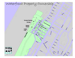
Short Description: The 1998 land parcel property ownership information for the waterfront catchment area comprising our Harlem on the River waterfront park project by tax lot.
Data Details: The basemap polygons are New York City Department of City Planning (DCP) tax block and lot land parcels as obtained on October 1998 through their BYTES of the BIG APPLE™ project. The street names were included with the package. The companion Property Value Index page listing the land parcel owners was graciously compiled and donated by the New York City Department of Finance from their "RPAD" property data. The catchment area shaded in green and the other lot descriptive names (re: Fairway, Fairway Parking, Cherry Walk, Cotton Club, Reality House, MTA Bus Depot, and Riverside Community) were incorporated into the design by the WE ACT GIS Mapping Specialist. Magnetic north is up.
Credits: Map prepared by Carlos M. Jusino at West Harlem Environmental Action, Inc. (WE ACT) using ArcView® GIS v3.1 software from the Environmental Systems Research Institute, Inc. (ESRI).
Support: Funded in part by the former W. Alton Jones Foundation (now Blue Moon Fund) and by the National Institute of Environmental Health Sciences (NIEHS).
Map Maker’s Notes: This simply formatted map is devoid of the credit and support information listed above. It was primarily designed as a very easy to read information tool for the Harlem on the River steering committee members, but it has also been often requested by community residents interested in the project.